
Eywa project for forest protection
For this past summer alone, the Spanish government's Council of Ministers approved allocations of more than 1,889 million euros to alleviate the effects of the 120 fires that have occurred. It also declared territories in all the communities to be "areas seriously affected by civil protection emergencies". With the exception of Cantabria and Asturias.
If we add the approximate cost of 10,000 euros per hectare to put out a fire, we realise the need to seek solutions to control the state of our forests and natural protected areas.
To all this economic data we must add the ecological disaster and the time that natural spaces need to regenerate, and that, according to experts, many of them will be irrecoverable as we lose the biological genetic essence and many unrepeatable natural spaces.
As well as affecting the fauna that forms part of the different biotopes. And, of course, our inland and rural tourist industry.
This is just one example of the cost of not being on time in the detection and control of fires in our country.
It is our responsibility to offer low invasive, economically viable and advanced solutions to reduce this situation.
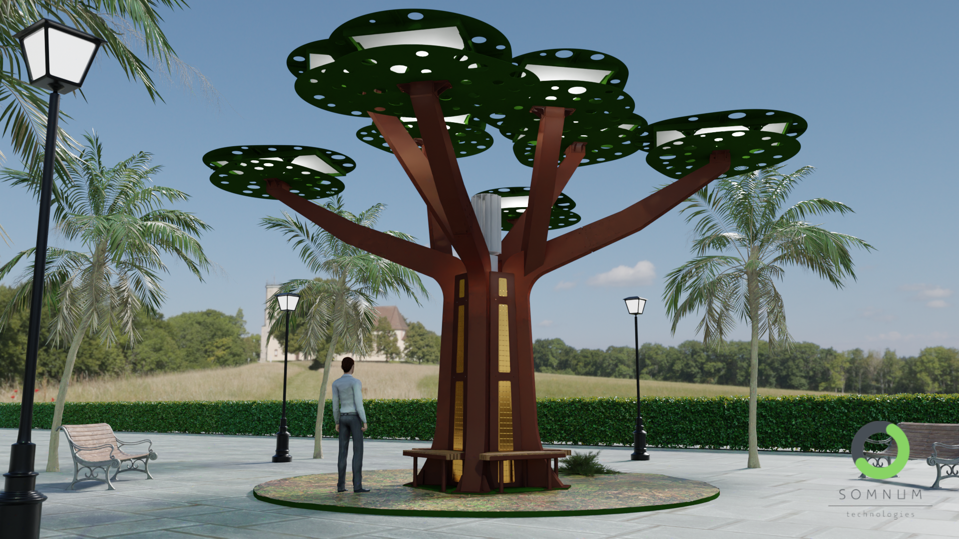
Our proposal unites high technology computing, electronics and telecommunications, as well as a predictive model based on real-time data collection through an active array of low-cost sensors within an intelligent model with secure alarm status, controlled from an advanced predictive control centre. In addition, we will apply the most advanced UAS technologies to check and monitor the alarms generated from the array, as well as direct action by fast-acting drones on outbreaks to reduce or extinguish the base of the fire. In addition to providing surveillance and deterrence for possible human actions in the security zones. All from a single control centre for the entire system.
Most fires are caused by arson. The existence of these systems will mitigate the actions and reduce these acts knowing that they are under active surveillance of an automated system operating 24 hours a day. In addition, the smart sensor array will generate basic upstream propagation information, which is the time between the start of the wildfire and the start of the extinguishing effort. This time is key in controlling the impact of the fire.
This phase is determined by three factors: the accuracy and effectiveness of the detection, the mobilisation time of the extinguishing teams and the difficulty of the approach of the vehicles to the area of the fire.
vehicles to the fire area.
Thanks to the architecture of the application and the real-time systems, the extinguishing teams will have a very useful information tool to help them in their work.
In addition to generating graphs of the matrix, we will be able to know the state of our forests, temperature, humidity, smoke...
This will help us to prevent situations and increase surveillance in certain areas where the data will define areas of "imminent risk".
The result will be an intelligent network of sensors with data transfer, routing and reception technology. This will automatically generate alarms and allow us to make quick, even automated, decisions to ensure that the outbreaks remain just that, outbreaks of fire, and do not escalate.
This is our challenge. And, we believe, everyone's challenge.
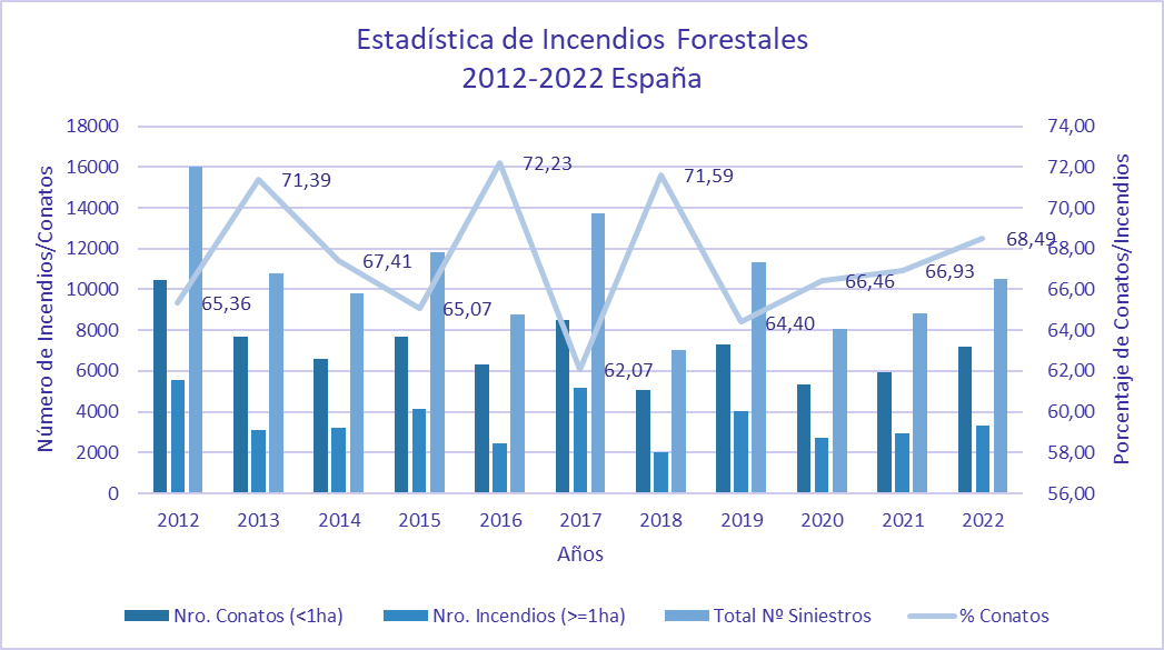
According to satellite data, Spain will close 2022 with almost 310,000 hectares of forest destroyed by fire, 40% of the total in the European Union (EU), making 2022 the worst year in terms of fires in the country so far this century and the fifth worst since records began.
Data from the European Forest Fire Information System (EFFIS), which bases its estimates on Copernicus satellite imagery, reported that the area of forest burned in Spain rose to 308,112 hectares, 3.6 times more than in 2021 and well above the average between 2006 and 2021 (66,793 hectares).
This project aims to help reduce these figures year by year and to ensure that our forests conserve their natural biodiversity so that future generations can enjoy them.
It is our responsibility.
There is still time.
> Official Fire Statistics in Spain :
Definitions:
- Conato: fires affecting an area of less than one hectare.
- Fire: any fire equal to or larger than one hectare.
- Great Forest Fire (GIF): sub-type of fire. They receive this designation when the area burnt is equal to or greater than 500 hectares.

Technical Abstract (Confidential Development Data under NDA on request)
So far, it is undeniable that the systems used to generate information on the state of forests and possible fire alarms have been either unsuccessful or insufficient.
We strongly believe that the incorporation of an active intelligent modular sensor array in the wilderness network will provide sufficient information, and in real time, to make quick and effective decisions. In addition, it will provide important data on the environmental status of the areas monitored by the array at all times.
The computing/processing unit integrates microcontrollers with solid state memory, analogue and digital inputs and outputs for the intended sensors and extra accessories according to applications at each node location and their needs. This development is based on an own patent. Spanish Patent No. ES1289917.
The foreseen sensors connected to the NS(Node) are:
- Temperature Sensor
- Motion sensor/Accelerometer
- Smoke/gas sensor
- Humidity Sensor
- Light Sensor
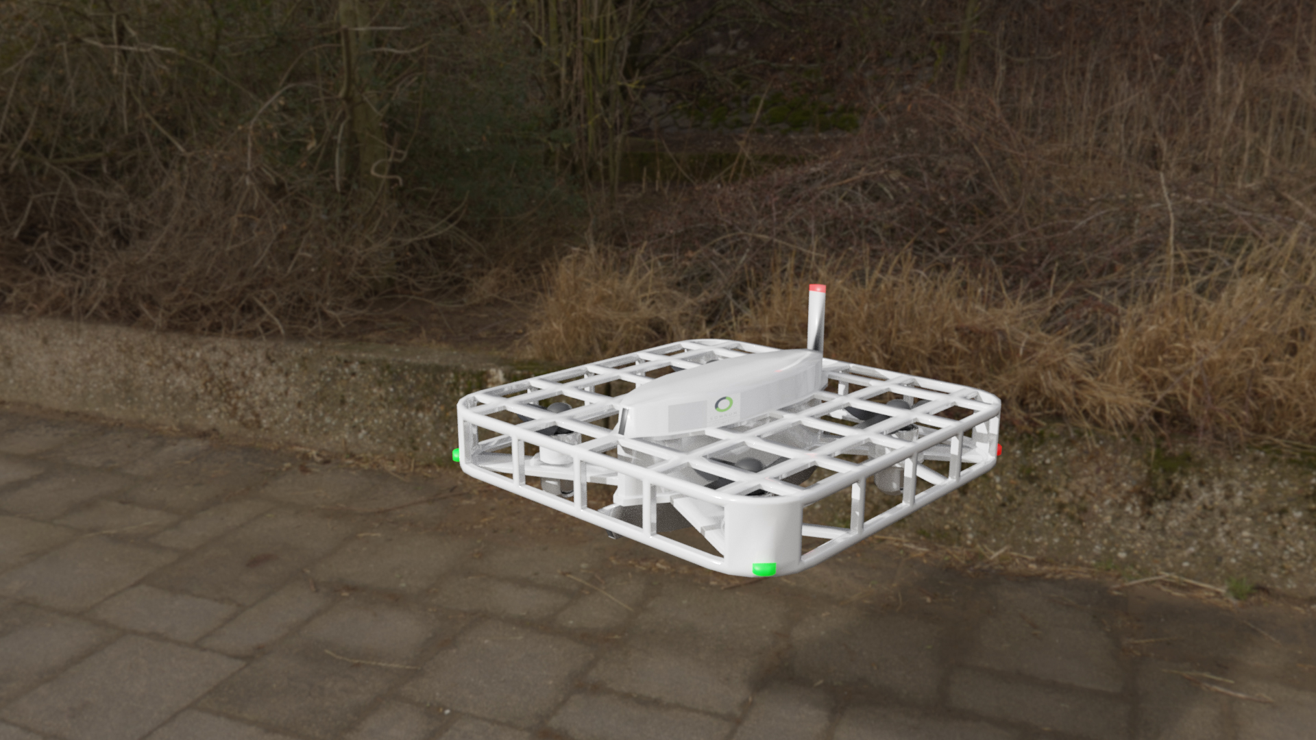
When the matrix detects a real alarm that generates a defined risk within the established parameters, it will automatically send the verification Drone to the specific area to check if the data we are receiving is real. This Drone will embark a thermal and optical camera and will proceed to check the area marked by the system and the surrounding area, locating, if necessary, the possible outbreak of fire in early and controllable moments. At that moment we will obtain thermal and non-thermal images of the outbreak. Being able to make decisions about the actual outbreak.
At that moment the human team in the control centre will be able to activate the fire outbreak alarms knowing:
- The exact position of the fire outbreak. With thermal and real images.
- Even video in real time.Magnitude of the outbreak. Size and extent.
- Measurement of the outbreak. Telemetry.
- Wind speed and direction for simulations.
- Temperature taken by the Drone and temperature of the area.
- In addition to all the data obtained by means of the Smart Sensor System.
As a help at the moment the Eywa project allows the control console to send another drone prepared with 25-50 litres of retardant so that it can surround the fire helping to extinguish or delay its spread to other areas.
These larger drones will help the extinguishing team to arrive in time so that the fire outbreak remains just that, an outbreak, and does not spread further into adjacent areas.
Project Information
Client:
World
Location:
Spain, for now.
Launch date:
~4th qtr. of 2023
Website:
In Process
TEAM PROJECT